Loading panorama viewer ...
Configuring ...
© 2016 Rolf Ris, All Rights Reserved.
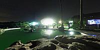
Caption
Close to the Blyde River canyon I relaxed in a pool looking to the stars.
The sky looks so different in the southern hemisphere.
It is a privilege to be able to travel to such famous places.
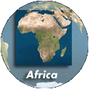
Location
Lat: 25° 57' 47.29" S
Long: 30° 50' 44.27" E
Elevation: 1412
Precision is: Unknown / Undeclared.
Equipment
Theta-S from Ricoh
 Tap or click the zoom icon in the bottom right corner of the picture to switch between in-page and fullscreen view