
© 2023 Andrew Bodrov,
Some Rights Reserved.

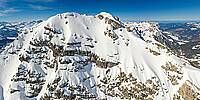
Zuger Hochlicht is located in the Lechquellengebirge, a mountain range that stretches west of the famous village of Lech. The name Zuger Hochlicht comes from the village of Zug, a settlement with only a few houses and hotels at the base of the mountain. The Zuger Hochlicht is with its 2371 meters not particularly high, but it does offer great views due to its prominent location high above the Lechtal Valley. From the summit you can see many of the main peaks of the Lechquellengebirge including Mohnenfluh (2544m) and Braunarlspitze (2649m), but also some of the major peaks of the Lechtal Alps are visible, like Rüfispitze (2640m), Trittkopf (2720m) and Valluga (2811m).
Zuger Hochlicht can be climbed all year long. In summer the mountain is often climbed together with its higher neighbor Mohnenfluh (2544m). From the saddle that separates the 2 mountains (Mohnenfluhsattel), a marked trail leads up to both summits. This upper part to the summit of Zuger Hochlicht is even fixed with steel cables to ease the ascent, but in my opinion these cables are completely unnecessary, since the path up to the summit is just a walk-up. The Hochlicht can be climbed in winter as well. Due to the vicinity of the Steinmahder chairlift, climbing Hochlicht is quite easy. From the top station you can ether go directly up the East Face (somewhat steep) or go the the Mohenfluhsattel and follow the steel cables up the North ridge to the summit. This last route takes some more time, but is an easier alternative. If you’re planning on climbing Zuger Hochlicht, wether it will be in winter or summer, the views make for a worthwhile trip.
Lat: 47° 13' 56.13" N
Long: 10° 6' 13.758" E
Precision is: Medium. Nearby, but not to the last decimal.
DJI Mini 2 Pro
 Tap or click the zoom icon in the bottom right corner of the picture to switch between in-page and fullscreen view