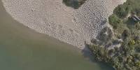

The Mouth of the Carmel River
Carmel-by-the-Sea, California, USA
June 17, 2005 - 18:17 PDT
Loading panorama viewer ...
Configuring ...
© 2005 Brooks Leffler,
Some Rights Reserved.

Caption
"The Carmel is a lovely little river," said John Steinbeck in Cannery Row. "It isn't very long but in its course it has everything a river should have."The river is only about 30 miles (48km) long, but it provides fresh water for the cities of the Monterey Peninsula; it marks the northern terminus of the famed Big Sur Coast; and its headwaters are a breeding ground for the steelhead trout.
Years of overpumping the river's aquifer have meant that the river's flow sometimes doesn't reach the sea at all, and almost never in the summertime. This year has been an exception, with double the normal rainfall – though this scene will be sandy beach and the lagoon landlocked in another month.
To avert winter flooding of properties around the lagoon, a channel is cut through the sand bar that forms when the stream goes dry in the summer. This year the Fish & Game Department requested that the swollen stream bed be routed to the north instead of straight through the bar, to slow down the drainage of the wetlands lagoon so the steelhead fingerlings aren't washed out to sea too early. The result has been heavy erosion of the beach, with part of the parking lot being washed away, and an ancient cypress tree and the scenic road around the beach being threatened, and many residents are upset.
The Carmel River epitomizes the conflict over scarce water that is a central part of California life. Demands for drinking water and flood control are countered by the demands of sport fishermen and environmentalists and no-growthers, and satisfying all sides is nearly impossible.
See other panoramas, both airborne and groundbound, on http://www.brooxes.com/
Location
Lat: 36° 32' 18.61" N
Long: 122° 56' 38.3" W
Elevation: 30 meters
Precision is: High. Pinpoints the exact spot.
Equipment
Nikon 8700 with FC-E9 fisheye adaptor, mounted on
Brooxes Flying Fisheye Platform, suspended from KAPilot 50 kite;
Radio-controlled shutter through gentLED serial trigger.
Image processed with PTMac 3.0, Photoshop CS with Noise Ninja plug-in, Pangea PanoPreviewer, and ClickHere Design's CubicConverter.
Other Solstice/Water Panoramas
My original intention was to submit an aerial view of the Edmund G. Brown California Aqueduct, which carries water from the Sacramento/San Joaquin Delta nearly 450 miles (724 km) south to quench the thirst of the Los Angeles basin. Alas, no wind on the day I tried – but I did get a presentable panorama on the ground, which you may see here.The Monterey Bay Aquarium is one of the world's finest, and I also shot a solstice panorama of their centerpiece exhibit, the 10-meter high Kelp Forest.
 Tap or click the zoom icon in the bottom right corner of the picture to switch between in-page and fullscreen view