

Loading panorama viewer ...
Configuring ...
© 2006 Rodolpho Pajuaba, All Rights Reserved.
Caption
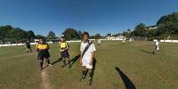
Even though Brazil has not gone THAT well on this 2006 World Cup, people around the world know that this country is an endless source of good football players. I tried to portray one of the reasons in this pano. This is one of the matches of a local, small championship that was happening during the timeframe for this event - and certainly there is another one happening now, as you read this. And we don´t need the best conditions: the field is not exactly perfect, the uniforms barely deserve this name (each one has his, and their ages vary a lot), but the will to (fair)play is here, in every child that dreams to become another Ronaldo, or simply wants to enjoy this national fever.
Location
Lat: 26° 24' 38.52" S
Long: 50° 18' 25.99" W
Elevation: 969m
Precision is: High. Pinpoints the exact spot.
Equipment
Canon EOS D60, Peleng 8mm lens, monopod. Stitched with PTGui/Smartblend, minor retouches in PS CS2.
 Tap or click the zoom icon in the bottom right corner of the picture to switch between in-page and fullscreen view