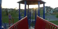

Evergreen Commons Park - Children's playground
Calgary, Alberta, Canada
June 20, 2008. 9:27 MDT (Local Time)

Loading panorama viewer ...
Configuring ...
© 2008 Lucia Bazan,
Some Rights Reserved.

Caption
I could not think of a location for this WWP event. Calgary itself is higher than Vancouver, where I lived until recently.Calgary is located at the transition zone between the Canadian Rockies foothills and the Canadian Prairies, and is relatively hilly as a result. Calgary's elevation is approximately 1,048 metres (3,440 ft) above sea level downtown, and 1,083 metres (3,553 ft) at the airport. Don't know the elevation for South Calgary, I assumed is a little higher, as it is on top of the hill.
Location
Lat: 50° 54' 31.63" N
Long: 115° 8' 12.86" W
Elevation: 1,048 m (3,438.3 ft)
Precision is: High. Pinpoints the exact spot.
Equipment
Nikon D50
 Tap or click the zoom icon in the bottom right corner of the picture to switch between in-page and fullscreen view