
Loading panorama viewer ...
Configuring ...
© 2008 Marc Gruber, All Rights Reserved.
Caption
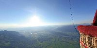
Rhine Valley of Saint Gall, Switzerland, view to Saentis, Bodensee, Austria and Principality of Liechtenstein.Slow-fly trip over the mountains of switzerland
Sorry for the bad guy face. I had fear about my equipment and it's unusual to see myself on a panorama. I've forgotten to smile. It was also my first take off with a hot-air balloon, the next try will be more professional. Maybe I'll install a 3m long telescope downward or horizontal outside. Anyway, it was a amazing trip and i felt like a free bird with GPS support.
Location
Lat: 47° 13' 11" N
Long: 9° 25' 36" E
Elevation: 2300m
Precision is: Medium. Nearby, but not to the last decimal.
Equipment
Shot taken with Canon 350D and Sigma 8mm F3.5 in a hot-air balloon
 Tap or click the zoom icon in the bottom right corner of the picture to switch between in-page and fullscreen view