
A Mixed Outlook
Sulzbach-Rosenberg, Bavaria, Germany
Sunday 22nd, 2008 - 17:06 UTC, 19:06 local

Loading panorama viewer ...
Configuring ...
© 2008 Markus Altendorff, All Rights Reserved.
Caption
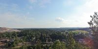
The Schlossberg ("castle mountain") is the main viewpoint on Rosenberg, the industrial half of the twin town of Sulzbach-Rosenberg.
The monument we're standing on dates back to the 1920s and lists the names of the fallen soldiers of WW I.
The eponymous castle vanished much earlier. According to writings of the chronologist Braun (1615), nothing but ruins remained of what most likely was a refuge.The distinctive elevation of the Schlackenberg ("slag mountain") to the right of the former steel mill is the lasting result of almost 150 years of industrial steel production. In its prime, the Maxhütte steel mill, now in the process of being dismantled, elevated the rural village of Rosenberg to a town with a population of several thousand.
Location
Lat: 49° 29' 28.35" N
Long: 11° 45' 57.47" E
Elevation: 400 m
Precision is: High. Pinpoints the exact spot.
Equipment
Hardware: Canon EOS 20D, Sigma 18-125mm@18mm, f/11. Manfrotto tripod and 303SPH pan head. Software: Stitcher 5.6, Cubic Converter, Adobe Photoshop CS3
 Tap or click the zoom icon in the bottom right corner of the picture to switch between in-page and fullscreen view