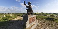

Checking for Gas
Teversal, Nottinghamshire, England, UK
Friday June 20th 2008 - 18:30 GMT

Loading panorama viewer ...
Configuring ...
© 2008 Steve Pendleton, All Rights Reserved.
Caption
"Checking for Gas" is a memorial to commemorate Nottinghamshire's coal mines and its mining communities and it stands on what is now the highest point in the county at 205 metres above sea level.This spot wasn't always the highest in Nottinghamshire but the statue itself is now standing on what was once one of the spoil tips from Silverhill Colliery.
The Colliery began operation in 1875 and at its peak employed over 1000 men and annually produced a million tonnes of coal. Production ceased in October 1992 leaving behind a legacy of its spoil tips actually forming the highest land in Nottinghamshire.
Nottinghamshire County Council undertook a partnership project with both the Coal Authority and Forestry Enterprise to reclaim and restore several colliery sites in the area with Silverhill now a part of the Teversal Trails series of walks.
The statue was created by the artist Antony Dufort and it was unveiled on the 21st of March 2005.
Teversal Trails - Silverhill Wood Walk - http://www.teversaltrails.com/silverhill.htm
See more of my panoramas at: http://www.fullscreenpanoramas.co.uk
Location
Lat: 53° 9' 15.07" N
Long: 2° 18' 51.31" W
Elevation: 205 metres
Precision is: High. Pinpoints the exact spot.
Equipment
Shot in RAW format with a Canon EOS 20D and Sigma 8mm Fisheye, mounted on a Nodal Ninja NN3 Pano Head and Manfrotto 190 tripod. Exposure was 1/250th of a second, ISO 100 at f8 with 4 portrait shots taken at 90 degrees apart plus zenith and hand-held nadir. Stitched in PTGui Pro on a PowerMac G5 and output to layered PSD. Cube faces created in CubicConverter, nadir patched in Photoshop and final movie output from CC.
 Tap or click the zoom icon in the bottom right corner of the picture to switch between in-page and fullscreen view