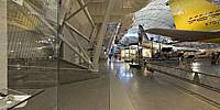
How Time Flies!
Dulles International Airport, Virginia, USA
June 21, 2009, 12:07 pm EST
© 2009 K. Wayne Heil, All Rights Reserved.
A variety of time pieces associated with flight are displayed along with other artifacts in the large exhibit case. The aircraft on display include the Concorde supersonic transport which reduced the flight time from New York to London to less than three hours. Manned flight increased the perceived speed of modern events and truly made time fly.
Lat: 38° 54' 42.78" N
Long: 78° 27' 40.17" W
Elevation: 300
Precision is: High. Pinpoints the exact spot.
Lens: Nikon 8 mm f2.8
Support: handheld
Stitcher: PTGui 8.2
Post Processing: Photoshop CS4
Conversion: Pano2VR


 Tap or click the zoom icon in the bottom right corner of the picture to switch between in-page and fullscreen view