
Two Guns, an American Ghost Town
Canyon Diablo, Coconino County, Arizona USA
27 June, 2011 - 1843 UTC (1143 MST)

© 2021 David Schaubert, All Rights Reserved.
Revisiting Two Guns Arizona, Ghost Town Extraordinaire
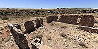
This pano was taken from the exact same spot as my 2011 History submission, using a mast rather than a tripod to provide a better view of the area. Not many changes year-to-year in the Desert Southwest. A rock falling here, blown dirt accumulating there. Even exposed wood from the 1800s merely shows deterioration due to sun exposure rather than rot. Most change is brought on by the human need to destroy things for no reason other than that they can.
Two Guns is no different. Due to its location adjacent to an Interstate 40 off-ramp and its iconic painted "MOUNTAIN LIONS" sign facing the highway, a steady stream of curiosity-seekers pass through the ruins every day. Some are respectful, but many are immature examples of humanity and climb the ruins causing physical damage or purposefully deface the ruins with paint or trash.
Not much change is readily apparent in the panorama, but a close comparison with the 2011 version will show displaced stone and crumbled walls.....and graffiti.
The modern history of Two Guns began 23,000 years ago when a meteor slammed into the Earth 7 miles away digging a mile-wide crater and killing all life within a hundred-mile radius.
As time passed, the area was settled by the Navajo and Apache tribes between 1000 and 1300 AD and became a chronic battleground. In 1878, at the present town site, below the Canyon Diablo rim, an opening into an extensive series of caverns formed by deep cracks in the ground caused by the meteor impact, became known as the "Apache Death Cave" after 42 Apache warriors were trapped and suffocated by a large fire set at the entrance by throwing down brush and trees from the rim 250' above.
The area saw much conflict during the pacification of the Apache and Navajo by the US Cavalry. A short but significant event also occurred when there was a run on harvesting the meteoric iron (high in platinum) left scattered on the surface from the nearby impact.
A series of trading posts were established above the canyon and with the coming of the National Old Trails Highway (soon to be known as US Route 66 in 1926) the town became a tourist trap complete with a menagerie, gas station, Apache Death Cave Tours, and trading post. As the path of Route 66 was changed to the north, the town (and its tourist trappings), also relocated with it.
The town survived until the late 1960s, when the latest incarnation of the trading post burned to the ground after renovations. The coming of Interstate 40 finished any real activity in the area, and a KOA Campground built at the Two Guns Interstate 40 exit died out in the '80s.
An extensive history of the town was written in 1968 and has been published on the internet at the link below. Definitely an interesting read.
Today the town site is open to anyone to explore and the picturesque Route 66 concrete bridge built over the canyon in 1926 is still in use. The town has been reduced to foundations and standing stone walls (the primary building material used).
This panorama was taken from the back deck (and lid of the building's 12' deep cistern) of the 1920s trading post. Across the canyon to the right of the bridge is the original trading post and Apache Death Cave. Beyond the bridge is the ruins of the more recent phases of the town as it was relocated further north following the rerouting of Route 66.
Canon XTi (400D) DSLR, Sigma 8mm f3.5 fisheye lens, Nodal Ninja 3 (NN3) Pano Head, MegaMast 28' Carbon Fiber Stand, Apple MacBook Pro 2010, PTGui Pro 11.31, Photoshop CS5 Extended, Pano2VR 5.2.5
More photographs and panoramas from Two Guns and Eastern Arizona http://www.6t6kix.com/pages/rt66/az_e.htm
History of Two Guns Arizonahttp://www.hkhinc.com/arizona/twoguns/richardson.htm
 Tap or click the zoom icon in the bottom right corner of the picture to switch between in-page and fullscreen view