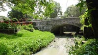
Puente de Panzacola,
Coyoacan, México City, México
Sunday, 19 september 2004. 11:00 local time (GMT -5, daylight saving time)
© 2004 Felipe González, All Rights Reserved.


Coyoacan, México City, México
Sunday, 19 september 2004. 11:00 local time (GMT -5, daylight saving time)
© 2004 Felipe González, All Rights Reserved.
PLEASE RESPECT THE ARTIST’S WORK. All images are copyright by the individual photographers, unless stated otherwise. Use in any way other than viewing on this web site is prohibited unless permission is obtained from the individual photographer. If you're interested in using a panorama, be it for non-profit or commercial purposes, please contact the individual photographer. The WWP can neither negotiate for, nor speak on behalf of its participants. The overall site is copyright by the World Wide Panorama Foundation, a California Public Benefit Corporation. Webdesign © by Martin Geier www.geiervisuell.com