

Loading panorama viewer ...
Configuring ...
© 2004 Pat Rooney, All Rights Reserved.
Caption
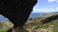
This natural bridge resulted from volcanic activity and weathering on Koko Crater, a mountain that helps form the southeastern tip of O'ahu, Hawaii.Most of the volcanic activity occurred perhaps 30,000 years ago on this, the newest part of the island. Between then and now softer rock has eroded from underneath harder rock creating an opening that grew gradually. The opening underneath the arch spans about 10 meters (33 feet) long by 2.5 meters (8 feet) high at the center. The arch itself is 2 meters (6.5 feet) thick top to bottom at the center. Judging by the loose rocks on which I set up for the panorama the opening is actively growing. Standing here you're on an incline of better than 45° - like being on a staircase covered in crumbly rock.
Steep as it is, it does serve as a bridge to adventurous hikers looking for a quick way to the peak of the crater. Check the link below to see a panoramic view from the top.
The only legend I could muster about this discerning but out-of-the-way formation involved Maui the demigod. The arch was the mug handle which he held while sipping cocoa from the crater. I couldn't substantiate this bit of lore, but I'll admit it looks a great deal like a mug handle.
Looking oceanside to the right you can see Koko Head rising above the horizon, and the inlet to Hanauma Bay just below. To the left (at least in the full screen version) you can see the parking lot for Hanaloa Blowhole, and on the horizon, between the lowest clouds and cloud shadows on the ocean, you can just barely make out the neighboring island of Moloka'i.
Check here to see more pictures of the arch and surroundings.
Unwrapped this panorama gives a spectacular effect.
Unwrapped this panorama gives a spectacular effect.
Check here for more stuffs by Pat.
Location
Lat: 21° 16' 52" N
Long: 158° 41' 54" W
Elevation: 200 meters, 650 feet
Precision is: High. Pinpoints the exact spot.
Equipment
 Tap or click the zoom icon in the bottom right corner of the picture to switch between in-page and fullscreen view