
Lake Shore Woonerf
Lake Shore Blvd and Lower Sherbourne St, Toronto, Ontario, Canada
september 23, 2006

Loading panorama viewer ...
Configuring ...
© 2006 aleksandar janicijevic, All Rights Reserved.
Caption
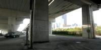
lakeshore woonerf, toronto, ontariothe gardiner expressway runs above lakeshore boulevard, along the shore of lake ontario, parallel to the railway tracks. a small city airport is nearby on one of the islands in the harbour, and airplanes fly by frequently. large ships delivering sugar to the nearby plant are also visible from this spot. the harbourfront art and entertaining centre by the lake is a tourist attraction so there is a lot of pedestrian traffic here too. as well, a main downtown residential area is just on the other side of the railroad tracks with a large indoor market, restaurants, theaters, etc.
this panoramic image has been significantly altered. can you guess what changes have been made?
this site is naked. all of the traffic regulating signs have been removed, as my contribution to one of the most revolutionary ideas in contemporary urban planning, an initiative called woonerf (naked street).
the idea is to introduce traffic calming zones by removing all traffic signs, lights, markings, signage and barriers, reducing the normal implied priority given to motor traffic; reintroducing eye contact between all the participants (social contact and self control instead of restrictions). a significant reduction in traffic frequency, speed, noise and injuries have been recorded by trials all over europe. while I don?t think that this idea is realistic in this particular spot, by implementing it in mixed urban/residential areas it would be one of the few things we could do to bring our aging cities back to health.
can you guess how many traffic regulating elements are visible from this spot, and have been removed from this panorama? 15? 30? wrong, there were 85 of them! please visit my website[http://www.urbansquares.com] for more information regarding research on the language of urban space with many urban square VR panoramas from all over the world. for urban enthusiasts, it is also a resource of virtual psychogeographical walks [dérives].
link to some interesting urban art: http://una.urbansquares.com/gallery
Location
Lat: 43° 38' 43" N
Long: 80° 22' 42" W
Elevation: 246 ft
Precision is: High. Pinpoints the exact spot.
Equipment
nikon d100, 18mm lens, kaidan panohead
 Tap or click the zoom icon in the bottom right corner of the picture to switch between in-page and fullscreen view