Defence Line of Amsterdam
Pampus, IJsselmeer, Netherlands
September 20, 2011, 11.45 am
© 2011 Jan van der Woning, All Rights Reserved.
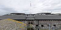
A panorama of Fortress Pampus, a part of the Defence line of Amsterdam, constructed on an artificial island in the former Zuiderzee, now called IJsselmeer. The Defence Line consists of a 135 km-long line of defences encircling the capital city, buttressed by 46 forts, and shows the dogged determination of the Dutch to defend themselves when necessary. Constructed between 1883 and 1920, water management and control played an important role in its design: the defence line could be operational within 48 hours by flooding the surrounding areas. These flooded areas, together with the forts would form a formidable obstacle to any invader. The water that was an enemy for ages was now used to fight an enemy. And that is what we need to do with fighting against an enemy that threatens our VR business by beating back with our knowledge and experience in VR Panoramic Photography. We should unite and be proactive to fight the patent that will otherwise change the way we work and earn our living. Not stay on the side and see how someone that is drowning is not saved but by helping and reach out a hand. The IVRPA is sponsoring an industry wide effort to overturn the '400 patent. The lawyers have a good handle on the prior art needed to prove our case but we need everybody's financial support to make this happen. Please be generous. Be one of the defenders of our VR industry.
If we don't work together for our common good we will confirm that we are easy pickings for these patent trolls because we are unwilling to defend ourselves as a group and unable to do so individually. The lawsuits have started. The faster we raise the needed money the faster we can end this. To learn more and donate to the effort please visit the IVRPA's '400 patent page.
Lat: 52° 21' 52.16" N
Long: 5° 4' 7.98" E
Elevation: 3 meter
Precision is: Unknown / Undeclared.


 Tap or click the zoom icon in the bottom right corner of the picture to switch between in-page and fullscreen view