
Remains of the Thirty Years' War
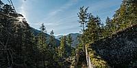
Porta Claudia at Scharnitz Pass, Tyrol, Austria
September 19, 2014, 06:42 UTC (08:42 local summer time)

Loading panorama viewer ...
Configuring ...
© 2014 Carl von Einem, All Rights Reserved.
Caption
From a path to a pass
Already at the time of the Roman Empire the route alongside the river Isar that you can see in this panorama developed into an important pass. What once was a bridle path through the Eastern Alps was upgraded to a fully developed Roman road, connecting what is now known as Italy and Austria in the South with Germany in the North. The early morning sun shows up in the East, so orientation in this panorama should be straightforward. Since the Romans controlled the whole area there was no need of a fortification during that time.The importance of this route continued throughout the middle ages, now known as part of the Via Imperii. Later in the early 16th century Martin Luther used this road on his journey back from Rome in the winter of 1511, still more than 100 years before a certain construction activity started.
A permanent fortification to guard the pass
The fortification named Porta Claudia was built between 1632 and 1634 during the Thirty Years' War as a protection against Swedish troops and the extensive looting that came with this devastating conflict. The Swedish troops never arrived but nonetheless the border fortification was further extended in later years.http://en.wikipedia.org/wiki/Mountain_warfare
In 1703 when during the War of the Spanish Succession Bavarian troops bypassed the Tyrolean forces by using a steep mountain path in the surrounding area and attacking the fortification from the other side. These first severe damages occured
When traveling to Italy in 1786 an impressed Goethe saw a huge wall that blocked the whole valley.
Just one hundred years later the Tyrolean army was tricked again, this time by Napoléon's troops. They found Bavarian guides who lead the way using the same path again. That path is still known as the "French Path" (Franzosensteig). Mit der Weiterentwicklung von Waffen (und neuen politischen Bedingungen) wurden solche Festungsanlagen nutzlos fell into decay
Current situation
Those who follow a small sign uphill at this natural bottleneck created by the two mountain ranges Wetterstein in the West (our viewpoint) and Karwendel in the East will find a long stone wall between 6 to 8 meters (20-25 ft) high and about 90 cm (3 ft) strong. Here in the border region between Germany and Austria, partly hidden by the mountainous forest the ruins of an old and massive barrier can be seen along the flank of the mountain. It's not quite visible from the street in the valley below and current aerial imagery only shows a densely wooded area.It's not too difficult to climb the elevated walkway alongside the wall what once was the patrol path and get a nice overview over parts of what's still left of the complex. Several signs like remains of a chimney indicate that the original site had enough space to house a large number of soldiers and provided horse stables as well as storage facilities.
* Remains of the original Roman road were found close to a village nearby
Location
Lat: 47° 23' 43.464" N
Long: 11° 15' 40.212" E
Elevation: 1,105 m (3,625 ft)
Precision is: High. Pinpoints the exact spot.
Equipment
- Nikon D800E / Walimex f3.5 8mm
- Philopod
- Hugin 2014.0 RC4 build 4 / Pano2VR 4.5.1 / Photoshop CS6
- my bike
 Tap or click the zoom icon in the bottom right corner of the picture to switch between in-page and fullscreen view