

Loading panorama viewer ...
Configuring ...
© 2016 Erik Krause, All Rights Reserved.
Caption
- 54 images taken
- 45 images used
- 3 brackets at +/- 2 EV
- 15 tone-mapped images stitched
- 1 panorama created
- 14000 pixels width
- 7000 pixels height
There are a pretty lot of numbers that can be used to describe a panorama and even the digital panoramic image are numbers, lots of them. But no amount of numbers can substitute actually viewing it.
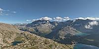
The Col Nivolet is drivable only on one side. The route was originally built for the two dams you see below and extended to the pass at 2612m to facilitate the access to the then new Gran Paradiso National Park.
Location
Lat: 45° 28' 34.42" N
Long: 7° 8' 42.61" E
Elevation: 2645m
Precision is: High. Pinpoints the exact spot.
Equipment
EOS 5D2, Samyang 12mm fisheye, SNS HDR lite, PTGui pro, Photoshop
 Tap or click the zoom icon in the bottom right corner of the picture to switch between in-page and fullscreen view