Micro Panorama Thumbnail for Social Sharing Sites

Revisited: Transportation

(July 1 - September 30, 2020)

Jim Zellmer

Above the Mississippi

John Wilson

Croydon Canal

Bromley, London, UK

October 11, 2020, 12.10 UTC

INFO: krpano 1.20.4 (build 2020-02-04)
INFO: HTML5/Desktop - WebGL
INFO: Registered to: Erik Krause
CLOSE
LAYERS
HOTSPOTS
PANO
KRpano/H

© 2020 John Wilson, All Rights Reserved.

Help
Caption

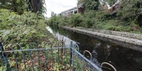
Opened in 1809, the Croydon Canal ran for 9.3 miles from Croydon to the Grand Surrey Canal at new Cross in South London. The canal enabled lime, timber, chalk and agricultural produce to be sent to London in exchange for coal being returned to Croydon.

The panorama shows one of the few remaining parts of the canal in Betts Park, South London. Another remaining part of the canal can be seen in the Dacres Wood Nature Reserve.

Location

Europe / UK-England

Lat: 51° 24' 35.9" N
Long: 1° 4' 54.4" W

→ maps.google.com [EXT]

Precision is: High. Pinpoints the exact spot.

30 km
20 mi
Leaflet | Map data © OpenStreetMap contributors
Equipment

Canon 500D, Sigma 8mm fisheye, Nodal Ninja 3 MKII VR head, Photomatix, PTGui, Pano2VR, Photoshop.

John Wilson

Croydon Canal

PLEASE RESPECT THE ARTIST’S WORK. All images are copyright by the individual photographers, unless stated otherwise. Use in any way other than viewing on this web site is prohibited unless permission is obtained from the individual photographer. If you're interested in using a panorama, be it for non-profit or commercial purposes, please contact the individual photographer. The WWP can neither negotiate for, nor speak on behalf of its participants. The overall site is copyright by the World Wide Panorama Foundation, a California Public Benefit Corporation. Webdesign © by Martin Geier www.geiervisuell.com