

Loading panorama viewer ...
Configuring ...
© 2007 Wim Gombeer, All Rights Reserved.
Caption
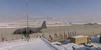
Not my very best pano from 2006 but a very significant one considering the location and circumstances. I was invited by the Belgian Army Forces to make a photoreportage of the Christmas & New-Year festivities at different bases (Lithuania, Afghanistan, Lebanon and Kosovo). The 30th December early in the morning I had the chance to climb the roof of the Kabul airport building (codename Airforce One) and see this incredible view. Flags were hanging halfdown because of a British soldier lost his life that day in Southern Afghanistan.More info @ :
http://www.globalsecurity.org/military/world/afghanistan/kabul_international.htm
The Kabul International Airfield has a runway length of 3,500 meters/11,483 feet.
Kabul International Airport belongs to the MoT, which operates KAIA. It is supported by the Troop Contributing Nations (TCNs). COM KAIA, under the command of COM ISAF, operates the military component of KAIA, assists the Afghan authorities in operating KAIA, and also assumes Air Traffic Control Authority in KABUL Control Zone (CTR).
The Afghan authorities retain responsibility for their respective Areas of Responsibilities (AOR). Inside ISAF AOR non-ISAF personnel are not admitted; however, ISAF-employees or guests on official business including personnel working at the airport for the Afghan Armed Forces or other governmental institutions will be permitted entry. Furthermore ISAF Rules of Engagement (ROE) are to apply, including authorization to use firearms. The same rules are to apply on KAIA outside the ISAF AOR, where ISAF or ISAF-chartered aircraft are being operated and/or parked.
Controlled Airspace - Kabul CTR - is established around the Kabul Airfield as class D airspace. The airspace extends to a 10 NM radius from the geographical center of the airport, vertically from the surface up to, but not including 12000 ft mean sea level (MSL). This airspace lies within and under Bagram Approach Control's airspace. Kabul airfield operates under VFR and IFR. IFR flights might be authorized within the Kabul CTR only on pilot request.
Equipment
Shot on Kodak Ektachrome with Seitz Roundshot 28-220, scanned with Imacon Flextight precision scanner.
 Tap or click the zoom icon in the bottom right corner of the picture to switch between in-page and fullscreen view