
Decomposing
The Andrews Forest Research Facility, Blue River, Oregon
June 21, 2009, 4:40 pm

Loading panorama viewer ...
Configuring ...
© 2009 Eva LaMar, All Rights Reserved.
Caption
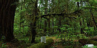
This is part of the Oregon State University forestry research facility known as HJ Andrews Experimental Forest.Photographed is an old growth forest that has an ongoing log decomposition study. The study will last over 100 years. They have already shown that there is more life in these logs than there is in a living tree.
The specific location of the study is not listed on this page. If you would like more information about the study, please contact the researchers through their web site.
The research program has been diverse throughout the history of the Andrews Forest, with the dominant themes changing over the years. Emphasis in the 1950s centered on systems for roading and for harvesting old-growth forests. Research in the 1960s focused on effects of logging on water, sediment, and nutrient losses from small watersheds. During the International Biological Program of the 1970s, basic studies centered on the workings of the forest and stream ecosystems, particularly in old-growth forests. In the 1980s, these basic studies continued under LTER and were augmented with applied research in silviculture, wildlife, landscape ecology, and other topics.
The central question currently guiding the Andrews Forest LTER studies is: How do land use, natural disturbances, and climate change affect three key ecosystem properties: carbon dynamics, biodiversity, and hydrology? These three ecosystem properties are of high scientific and social interest and represent three rather different categories of ecological response to landscape patterns.
This major heading in the web organization describes the ongoing research studies associated with the Andrews LTER and the Experimental Forest. Subsections will range from listings of projects to general overviews of research programs to detailed work plans. These can be about past, present or planned future projects.
The intent of having this material is to:
- Support proposals with more detailed method sections that can be referenced.
- Describe more fully the LTER participants the methodological approaches used.
- Provide outside reviewers with more detailed descriptions of methods than can be found in annual reviews, proposals, and in some cases, published literature.
Location
Lat: 43° 13' 3" N
Long: 123° 16' 5" W
Precision is: Low. Intentionally hazy, due to privacy concerns.
Equipment
Nikon D90 and Nikon D70, Nikkor 10.5mm lens, Nodal Ninja, Kaidan quick-tilt leveler, and lots of chocolate. Mac, iPhoto, Adobe Photoshop CS4, PTGui Pro, CubicConverter
 Tap or click the zoom icon in the bottom right corner of the picture to switch between in-page and fullscreen view