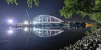
The Night Before The Big Move
Osthafenbrücke, Frankfurt/Main, Hessen, Germany
August 22, 2012, 00:30 CEST
© 2012 Gabi Haindl, All Rights Reserved.
Frankfurt is going to have a new bridge, connecting the city near the European Central Bank (also still under construction) and the Eastern Harbour with Offenbach.
The bridge was assembled on the northern river bank. The time the panorama was taken (end of the second day of the big move), the bridge was ready to be moved to its final location in one piece by using two pontoons. That means floating on the river, being pulled to the new place!
The schedule for placing the bridge over the river Main was delayed. The bridge should have been already swimming, but for later in night a thunder storm was announced. So for safety reasons, the bridge stayed on the river bank, but one end already projecting out on the river.
Lucky for me, otherwise I wouldn't have been able to take the panorama from this place. During the day, nobody was allowed to sit or stand on the stones.
The workers still were busy welding parts to the pontoon, so the scene was nicely illuminated.
To the left, behind the railroad bridge is the contruction site of the European Central Bank. The buildings with the cranes on top, have nearly reached their final height.
Although all the constuction sites had bright lights, the park behind me was not so well lit. Due to the stop of the move, all the lamps which were installed for the watching people were off, and only a few people were still around. So I ended up trying a HDR panorama with bracketing from 1/4s to 15s.
Some more panoramas from the days of the Big Move are on Kugelblick.


 Tap or click the zoom icon in the bottom right corner of the picture to switch between in-page and fullscreen view