
Ta-di Mountain Natural Park — 漯底山自然公園
Mituo Dist., Kaohsiung City, Taiwan — 高雄市 彌陀區
November 28, 2011, 08:11 UTC (16:11 TPE)

Loading panorama viewer ...
Configuring ...
© 2012 Walker Young, All Rights Reserved.
Caption
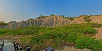
Ta-di Mountain Natural ParkTa-di Mountain is located in Ta-di Village, Mi-tuo Township. It has a length of about 800 meters and a width of about 600 meters. Its altitude at about 53 meters is the highest point in Mi-tuo Township. Due to the place being a military restricted area that has not been opened to the public for a long period of time, for the people from Mi-tuo Township or the large and small Gangshan districts, Ta-di Mountain had been perceived as a negligible small hill when viewed from afar. Until when Liao-song Cultural Layer was found under Ta-di Mountain, were Taiwan's unique badlands, that are closest to the seaside, gradually noticed.
Ta-di Mountain is a precious natural asset endowed to Mi-tuo Township by Mother Nature, and it had been a restricted military stronghold area. The military finally withdrew in 2006 and management of Ta-di Mountain was handed over to Mi-tuo Tonwship Office. Ta-di Mountain Natural Park was then established and its mystery was unveiled. Step by step, construction such as the hiking and recreational trails, viewing platform, and greenification of the wide outbound/inbound roads in Ta-di Mountain have all been completed, making Ta-di Mountain a great place for hiking and leisure activities.
漯底山自然公園
漯底山位於彌陀區漯底里,分佈的範圍長約八百公尺、寬約六百公尺,標高約五十三公尺是彌陀區的最高點。由於長期為軍事管制區並未對外開放,對於彌陀區人或大小岡山地區而言,漯底山從遠處眺望都像一座不起眼的小山丘。直到漯底山下的蔦松文化層被發現,使得這座台灣區最靠近海濱獨特的惡地形漸漸受到矚目。
漯底山是大自然賦予彌陀區的大自然珍貴資產,長期為軍方要塞管制區,直到直至民國九十五年軍方撤哨,交由彌陀區區公所代管並成立「漯底山自然公園」,方解開神秘面紗,經過一步一腳印的努力,漯底山已經完成了登山休閒步道、觀景台、植樹綠美化寬敞聯外道路工程,讓漯底山成為民眾從事登山休閒的好所在。
Location
Lat: 22° 46' 1.02" N
Long: 120° 15' 1.47" E
Elevation: 38.209
Precision is: High. Pinpoints the exact spot.
Equipment
Canon EOS 5DII + Sigma 8mm f/3.5 fisheye
Software: PTGui, Photoshop CS4
 Tap or click the zoom icon in the bottom right corner of the picture to switch between in-page and fullscreen view