
Borders Are All Around You
Canyon Country, California, USA
March 21, 2006, 13:35 PDT (21:35 GMT)

Loading panorama viewer ...
Configuring ...
© 2006 Pat Swovelin, All Rights Reserved.
Caption
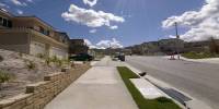
Borders are everywhere in your neighborhood.There's the curb on the right which is the border of the area where cars may drive. There's the white and blue painted area beside the street (above the drain opening at the edge of the street) that says "No dumping - Drains to Ocean" to remind you that this is the border with the Pacific Ocean and you shouldn't put bad things in there, just water.
Across the street we see a street light that, at night, is the border of the lit and unlit areas of the street. Below the street light we see a fire hydrant, the border for much needed water fire fighters use in an emergency.
There's the sidewalk in front of you that's the border between the street and the houses and is where people can walk safely.
There's a block wall wall on your left that's the border of someone's property. Behind that is their front door which is the border where you can legally go on their property without getting shot or arrested or invited in for a drink.
Above the black car in the driveway (only visible in the full screen version) are 2 airliners flying in opposite directions up and down the coast, they define a border of a north-south air route running along the west coast of the United States.
Looking to the left we see the end of the sidewalk and the new section of road, they define the border of the next phase of this sub-division project. In the new street are 2 short pieces of portable fence that are the border of where you can or can't drive depending upon your being a part of the construction crew. Looking past that we see orderly piles of construction material that are the border of where the construction crews will start to erect the new houses. Past that, in the background, we see the hills covered with black plastic that defines the border with the final phase of construction. At the far edge of that is the border of the outermost portion of the land that will be developed (i.e., turned into houses, ugh).
Looking down we see the sidewalk that is the border between us and the Earth itself while at the same time it's the border between the land and the air.
Looking back up again we see the hills and mountains in the distance and their topmost edge is the visible border between the Earth and the atmosphere, the thin mantle we call the sky, it's the horizon. The horizon is the biggest border of all, it's the difference between here and there. This, in its turn, is also the border between the planet we call home and the unfathomable vastness of the Universe itself.
Dang, that's a big border.
Location
Lat: 34° 24' 30" N
Long: 119° 27' 8" W
Elevation: 1546'
Precision is: Medium. Nearby, but not to the last decimal.
Equipment
Canon Digital Rebel (300D), 8mm Peleng lens, Bogen tripod, Nodal Ninja panohead, ISO 100, f 16, 1/160 second exposure, RAW, PTGui 5.8beta1, Photoshop CS, pano2QTVR, NBNC
 Tap or click the zoom icon in the bottom right corner of the picture to switch between in-page and fullscreen view