
Loading panorama viewer ...
Configuring ...
© 2010 James Gentles, All Rights Reserved.
Caption
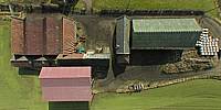
Fairniehill is typical of many small mixed-arable farms in lowland Scotland. Starting where the road leaves the farm and moving clockwise, a field of winter barley sown last year is already showing progress. This crop will be used to feed livestock with the surplus being sold. Continuing clockwise to the south the fields have been ploughed and seeded but it is too early to see signs of life. Livestock is still kept inside the farm steading at this time of year but, very soon, as the weather improves and the ground becomes less waterlogged, they will be grazed outside.
You may have thought this rural idol has been unchanged for hundreds of years, but let's look round clockwise once more starting from the farm road...
Beyond the Winter Barley is the Union Canal, built in 1820 to bring coal to the city of Edinburgh nearby, and bringing the Industrial Revolution to this part of Scotland. Continue clockwise to where the canal disappears. In the 1860s James "Paraffin" Young, having perfected the process of extracting paraffin and paraffin wax from shale, set up one of the world's first oil refineries here. The refinery was in the trees with the huge red "bings" of spoil to the right. For its day this industrialisation was a huge social change for this rural community. The discovery of crude oil made this process uneconomic at the start of the 20th Century - there are still reserves of oil in the ground here!
Changes in farming in the 20th Century mean that this steading is no longer a farm in its own right, but part of a larger farm thanks to modern farming methods and the economies of scale.
Despite all these changes this farm continues to provide grain for our table, spirit for our whisky, and top quality beef to the butchers of Edinburgh.
Location
Lat: 55° 58' 23.52" N
Long: 4° 32' 15.24" W
Elevation: 80m ASL + 50m AGL
Precision is: High. Pinpoints the exact spot.
Equipment
Nikon 8400 with FC-E9 Lens. Homemade camera cradle/rig, triggered by a
gentLED
intervalometer. Suspended below a Dan Leigh Trooper kite with 6ft/2m span.This technique produces two hemispheres, and a different workflow in PTGui from the classic ground pano technique. This results in lower resolution BUT impossible angles!
See the rig, how Kite Aerial Photography is achieved, and the workflow.
Behind the scene : how this panorama was made
The week before WWP I had visited the farm site and discounted a more picturesque
farm steading because of overhead power lines. This location still had buildings
that were over 200 years old but it was less busy with less equipment to see outside.The challenge with WWP is getting the right wind and the right light within the shooting window. With the weather closing in I choose my day and arrived with a much stronger wind that I would have liked. I choose to fly the "Trooper" kite, specially designed for high wind, with a 50foot tail to help stability.
Once high in the sky the kite became stable enough to attach the camera that weighs 1.4Kg (3lbs). Always a nervous time as the fisheye lens has no protection should it touch the ground.
The camera automatically took around 150 images, hopefully you like the results!
 Tap or click the zoom icon in the bottom right corner of the picture to switch between in-page and fullscreen view