

Loading panorama viewer ...
Configuring ...
© 2012 Dean Karamehmedovic, All Rights Reserved.
Caption
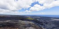
Jack Thompson was the last full-time resident of the Royal Gardens subdivision, his house is also open as a Bed and Breakfast for those seeking a truly isolated retreat! For many years since 1983 Madame Pele spared Jack Thompson’s home and the lava flow continued down to the ocean. On numerous occasions, lava flows have veered around Thompson’s home, miraculously sparing it from the same fate that every other structure has been dealt. On the evening of Friday, March 2, 2012, a fast moving lava flow from the Pu`u O`o crater four miles up overran his residence and his house was destroyed.Thompson and lava photographer Leigh Hilbert were airlifted out of town by helicopters just before nightfall as the lava was an estimated 100 feet from the home.
For those who who would like a birds-eye view of the action, a helicopter tour is an amazing alternative, I highly recommend Blue Hawaiian Helicopters who made this project possible.
Alternative View
Alternative View
Photo from Dec, 2011
Mahalo
Location
Lat: 19° 21' 14.91" N
Long: 156° 3' 49.42" W
Elevation: 1290
Precision is: High. Pinpoints the exact spot.
Equipment
Canon 5D MK2, Tokina 10-17mm
 Tap or click the zoom icon in the bottom right corner of the picture to switch between in-page and fullscreen view