

© 2025 J Pat Marse, All Rights Reserved.
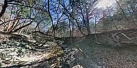
The Chisholm Trail was the major trail used for driving cattle from ranches in southern Texas northward through Indian Territory (now Oklahoma) and ending at the rail stops in Kansas after the Civil War. Only in use from 1867 to 1884, it was nevertheless important in the recovery of Texas after the war.
The view of this spring-fed stream on the trail is now shielded from above by substantial forested growth. Low hanging nearly invisible branches made taking this panorama by drone beneath the treed canopy very risky but after much careful scouting an unobstructed safe place to launch the drone was found.
Lat: 31° 19' 57.5" N
Long: 98° 14' 54.5" W
Precision is: Low. Intentionally hazy, due to privacy concerns.
DJI Mini III Pro, Pano2VR, PTGUI Pro Version 12.26, Photoshop Elements 2021
 Tap or click the zoom icon in the bottom right corner of the picture to switch between in-page and fullscreen view