
An Elevated View in an Elevating Landscape
Fäberget mountain, High Coast World Heritage, Sweden
June 21, 2008 - 11:06 UTC (13:06 local time)

Loading panorama viewer ...
Configuring ...
© 2008 Jakob Norstedt-Moberg, All Rights Reserved.
Caption
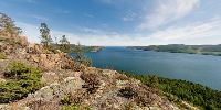
This is a panorama from a very nice elevated viewpoint in the High Coast World Heritage, "Världsarvet Höga Kusten".This area was nominated a UNESCO World Heritage in the year 2000 because of the continous uplift (elevation) of the land, currently about 1 meter per 100 years.
During the last glacial period the land was depressed by the very heavy ice coverage with a thickness of about 3000 meters. The ice melted and finally retreated from this area 9600 years ago and since then the land has rised up from the Baltic sea (Bottenhavet), up to now 285 meters of altitude. New land is continously appearing, bays are transformed into lakes and the harbours are getting shallower.
Out to the east, in the initial direction of the panorama, you can see the islands of Ulvön with a fishermens wharf (Ulvöhamn) well known as the capital of the fermented Baltic herring, the Surströmming.
To the south, over the Ullångersfjärden fjord, you see the peninsula of Nordingrå and to the north, not visible behind this mountain of Fäberget, is mount Skuleberget with a visitors center Naturum Höga Kusten. Further north is the Skuleskogen National Park.
A panorama tour of the High Coast World Heritage
More about the High Coast (in Swedish)
Equipment
Nikon D3, Shaved Nikkor 10.5mm Fisheye, Agnos MrotatorTCP head, 4 images
 Tap or click the zoom icon in the bottom right corner of the picture to switch between in-page and fullscreen view