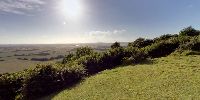

The Weald of Kent from the Wye Downs
Wye National Nature Reserve, Kent, England, UK
22 June 2008, 1735 GMT (1835 British Summer Time)

Loading panorama viewer ...
Configuring ...
© 2008 Richard Crowest, All Rights Reserved.
Caption
This panorama is a return to the location of an earlier contribution, but at the opposite end of the year.The Downs of southern England are ridges of hills, the remains of an ancient seabed that was pushed up and then eroded, leaving steep chalk ridges to the north and south. Between the ridges lies the Weald, a pastoral mixture of woods and farmland. The eastern end of the North Downs forms the famous white cliffs at Dover, the location for another World Wide Panorama contribution.
For me, this is a favourite spot for a stroll, particularly at the end of a long summer day. The light constantly plays across the landscape, so the view is never the same twice. Standing above that great sweep of countryside, you feel connected to both earth and sky, the hills providing spiritual elevation as well as the physical kind.
Location
Lat: 51° 10' 8" N
Long: 0° 58' 4.26" E
Elevation: 112m
Precision is: High. Pinpoints the exact spot.
Equipment
Canon EOS 450D, Sigma 8mm fisheye lens, bracketed exposures blended with Bracketeer and stitched in Autopano Pro.
 Tap or click the zoom icon in the bottom right corner of the picture to switch between in-page and fullscreen view