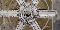

Disused Navy Accommodation Block
Treasure Island, San Francisco Bay, California
Friday 20th May, 22:06U 15:06PST
Loading panorama viewer ...
Configuring ...
© 2016 James Gentles, All Rights Reserved.
Caption
Do many people use the freeway exit at the tunnel in the middle of the Bay Bridge? It leads to former Naval Base "Treasure Island", which if nothing else has spectacular views of San Francisco Bay. Seems the Navy left, and before its planned re-development what's left has seen better days. I guess it's unique?
The opening north-westward view shows a run down military accommodation block with 6 "wings" off a central stair and service way. Pan down to see a second similar accommodation block at close quarters!
Location
Lat: 37° 49' 15.75" N
Long: 123° 23' 22.85" W
Elevation: 40m
Precision is: High. Pinpoints the exact spot.
Equipment
4 GoPro HERO2 cameras, with a wooden camera cradle/rig to hold the cameras
in exactly the correct position is triggered by 4
gentWIRE camera
syncronisers. Suspended below a Rokakku kite.This technique produces two hemispheres, and a different workflow in PTGui from the classic ground pano technique. This results in extra effort BUT impossible angles!
See the rig, how Kite Aerial Photography is achieved, and the workflow.
 Tap or click the zoom icon in the bottom right corner of the picture to switch between in-page and fullscreen view