
El Rey Mayan Ruins Part 2
Hotel Zone Kukulcan Blvd Km 17, Cancun, Mexico
1:36p Central Cancun MX Time UTC -6

Loading panorama viewer ...
Configuring ...
© 2014 Pat Albright, All Rights Reserved.
Caption
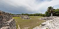
El Rey Ruins (Zona Arqueologica El Rey)The ruins El Rey (The King), is a post-Classic Period archaeological site located right in Cancun's Hotel Zone KM 17 near the southern end of the island. El Rey 47 structures include plazas surrounded by buildings and several platforms that are connected by a long grass pathway. The site takes its name from a skeleton uncovered there and thought possibly to be a former Mayan king.
There is one thatched roofed sun shade in the center of park. There are no concessions and bring a bottle of water.
Location
Lat: 20° 3' 42.65" N
Long: 87° 46' 52.72" W
Elevation: Elev 17 feet (6m) above Mean Sea Level
Precision is: High. Pinpoints the exact spot.
Equipment
Dell All in 1 64bit Intel i7 27" Touch Screen, Canon EOS 500d (Rebal T1i), Sigma 8mm fisheye, tilted up 5° - 4 raw images, SLIK monopod, Nodal Ninja Ultimate R1 and EZ-Leveler II, Photoshop CS6 (non Cloud) Adobe Camera Raw 8.6, PTgui Pro 64bit 10.06, Pano2vr Pro version 4.5.1 64bit Image converter.
 Tap or click the zoom icon in the bottom right corner of the picture to switch between in-page and fullscreen view