
The Old Harbour "Gammhamnen" at Storön Island, Erased by the Land Uplift
Storon, High Coast World Heritage, Sweden
May 11, 2007 - 13:40 UTC (15:40 local time)

Loading panorama viewer ...
Configuring ...
© 2007 Jakob Norstedt-Moberg, All Rights Reserved.
Caption
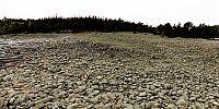
The High Coast, at the Gulf of Bothnia, was declare a World Heritage by UNESCO due to its high land uplift. The land has rised about 290 meters since the last ice age and still rises almost 1 meter (40 inches) in a century.In old days the lake to the right in the view was connected to the sea to the left (Check Google Maps). Fishermen had a good harbour with shelter for all kinds of weather.
In the 18:th century the sound became pretty shallow. The fishermen had to fight against the uplift in combination with the stones built up by the ice in wintertime and spend a lot of their time rinsing the sound for stones. In 1870 they finally had to surrender and accept the fact that the harbour had turned into a lake. The place is now called "Gammhamnen" - The Old Harbour"
These days there are hardly any traces of the harbour to be found. The island is inhabited but can be reached in summertime by a small boat leaving from Hörsångs Camping. The nature is very wild - another panorama can be found here: Cliffs of Storön. This is part of a panorama tour I made for the official website of the World Heritage. Press "Upplev Höga Kusten" for the full list of panoramas (unfortunately not yet in English).
Location
Lat: 62° 45' 51.48" N
Long: 18° 12' 32.4" E
Elevation: 4m
Precision is: High. Pinpoints the exact spot.
Equipment
Kodak DCS Pro SLR/n, Shaved Nikkor 10.5mm Fisheye, Agnos MrotatorTCP head, 4 images
Caption in [Swedish / svenska]
Höga Kusten vid Bottenhavet utsågs till Världsarv av UNESCO på grund av den höga landhöjningen och världens högsta marina kustlinje vid Skuleberget. Landhöjningen är fortfarande c:a 1 meter på hundra år.För länge sedan var sjön till höger i bild förbunden med havet till vänster. Fiskarna hade en fin hamn med skydd för alla väder.
På sjuttonhundratalet började kanalen bli ganska grund och fiskarna fick kämpa mot landhöjningen som i kombination med sten som isen pressade in ständigt försämrade kanalens djup. Man rensade och rensade men på 1870-talet fick man slutligen ge upp och acceptera att hamnen hade blivit en sjö. Platsen övergavs - därav namnet Gammhamnen.
Nu för tiden finns få spår av hamnen kvar. Storön är obebodd, men kan nås sommartid med en liten passbåt från Hörsångs Camping
Detta panorama är en del i en större panoramarundtur som jag gjort för Världsarvet på uppdrag av Länsstyrelsen i Västernorrlands län. Gå till Världsarvets officiella hemsida http://www.naturumhogakusten.se och klicka på "Upplev Höga Kusten".
Jakob Norstedt-Moberg Fotoverkstan
 Tap or click the zoom icon in the bottom right corner of the picture to switch between in-page and fullscreen view