
Loading panorama viewer ...
Configuring ...
© 2012 James Gentles, All Rights Reserved.
Caption
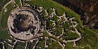
Broch of Gurness is an example of a defensive tower and village dating from 100-200 BC, common for the time in Scotland. The tower would have been some 8 metres high, but enough remains to get a good idea of the layout.The discovery of the broch is as interesting as the structure itself. In 1929 poet Robert Rendall was sketching on a grassy mound when of the legs of his stool sank into the ground. By removing some of the nearby stones he discovered a staircase leading down into the mound. Later that year a full excavation started leading to the discovery of the entire structure including defensive ditches.
Location
Lat: 59° 7' 26.04" N
Long: 4° 5' 52.32" W
Elevation: 3m
Precision is: High. Pinpoints the exact spot.
Equipment
4 GoPro HERO2 cameras, with a prototype camera cradle/rig, triggered by 4
gentWIRE camera
syncronisers. Suspended below a Dan Leigh Cruiser kite with 8ft/2.5m span.This technique produces two hemispheres, and a different workflow in PTGui from the classic ground pano technique. This results in extra effort BUT impossible angles!
See the rig, how Kite Aerial Photography is achieved, and the workflow.
 Tap or click the zoom icon in the bottom right corner of the picture to switch between in-page and fullscreen view