
Main Crater of Volcán Irazú
Volcán Irazú, Provincia de Cartago, Costa Rica
11:30 AM, CST

Loading panorama viewer ...
Configuring ...
© 2004 Ryan Edward Galt, All Rights Reserved.
Caption
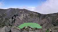
This is the main lookout over the Cráter Principal, the bottom of which is 300 meters below. On March 13, 1963, coinciding with the visit by U.S. President John F. Kennedy, Volcán Irazú began a marked period of activity, erupting ash and volcanic "bombs." Roofs in nearby towns collapsed under the weight of the ash. Agricultural activity, especially potato cultivation and milk production, was greatly reduced. According to the Ministerio de Agricultura y Ganadería, the eruptions affected over 45,000 hectares of agricultural land. Ash as deep as 1.5 meters accumulated quickly in the cities and towns of the Valle Central. The rainy season brought mudflows as the ash was washed through the deep gullies on the flanks of the volcano. A mudflow destroyed 400 houses in Taras de Cartago where the ash-water mixture was released from the gullies onto the valley floor. This strong eruptive activity continued into 1964. In that year a Costa Rican physician and Hungarian visitor were killed and a group of 50 people injured when they approached the crater while it continued to erupt. Since then, the Costa Rican government has prohibited tourist access to the craters. By 1965, activity had decreased to periodic releases of gases, and by March the activity ceased. In July 1965 a lake began forming in the principle crater. The lake level has fluctuated since then, disappearing some years in the dry season. The lake has been a permanent feature since 1991, though its color has changed from mustard to turquoise to green. To the west the highest point of Volcán Irazú is visible. To the east is Cráter Diego de la Haya, the site of the eruption in 1723, since filled with pyroclastic debris. To the south is Playa Hermosa, a flat area created by previous eruptions.
Equipment
Olympus C-5050 Zoom, standard lens, hand-held, RealViz Stitcher, Photoshop, CubicConverter
 Tap or click the zoom icon in the bottom right corner of the picture to switch between in-page and fullscreen view