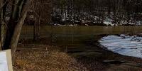

Wastewater Treatment Plant Discharge Point on the Susquehanna Greenway Trail
Oneonta, New York, USA
March 25, 2007 - 20:14 UTC (16:14 Local Time)

Loading panorama viewer ...
Configuring ...
© 2007 Julie Pecenco, All Rights Reserved.
Caption
The Oneonta Susquehanna Greenway is a recreational trail along the Susquehanna River in Oneonta, New York.While the proposed trail is to be six miles long, it is currently a much shorter loop of contrasting perspectives. Among these contrasts are numerous examples of stages in the water cycle in which the earth's atmosphere is a critical part. The southern part of the trail runs along the river, and numerous trail markers note the natural highlights of the area. The northern part of the trail follows Interstate 88, the only major highway in the area. Sandwiched within the loop are the Otsego County Waste Water Treatment Facility, the Solid Waste Facility (ie, dump), the City of Oneonta Transportation Center, the dog pound, and other public buildings.
The contrast between the nature trail and the waste we add into the water cycle and to the environment is most evident at the discharge point where treated waste water is dumped into the river. Amusingly, one of the trail markers highlights this location, and it is there that this panorama was made. Click the hotspots in the panorama to see legible close-ups of the signage. Next to the river, the primary sounds were the rushing of a river engorged with spring runoff and the songs of birds in the trees, but the rush of traffic along the interstate highway is never far away. Not evident in the panorama is the scent of sewage that permeated the atmosphere.
The water in the river, which begins at Otsego Lake in Cooperstown, flows south and eventually empties into the Chesapeake Bay. It evaporates into the atmosphere and eventually falls again as rain, or the snow which still covered much of the trail when this panorama was made. To this is regularly added the sewage of our human activities.
In June of 2006, heavy rains caused the flooding of the Susquehanna and other area rivers. The entire waste water treatment facility was flooded, and raw sewage flowed directly into the river for many weeks until the plant was fully repaired.
More QTVR by Julie Pecenco: http://www.learningtoflyoriginals.com/panorama.html
(includes two panoramas taken at the source of the Susquehanna River in Cooperstown, NY.)
June 2006 Flood images: http://www.learningtoflyoriginals.com/flood.html
Oneonta Susquehanna Greenway: http://www.oneontagreenway.org/
June 2006 Flood images: http://www.learningtoflyoriginals.com/flood.html
Oneonta Susquehanna Greenway: http://www.oneontagreenway.org/
Location
Lat: 42° 26' 8" N
Long: 76° 7' 24" W
Elevation: 1040 ft
Precision is: High. Pinpoints the exact spot.
Equipment
Camera: Nikon D70, Lens: Nikkor 10.5 mm fisheye, PanoHead: KingPano, Tripod: Bogen/Manfrotto 3021, Software: PTGui, Pano2QTVR Pro, Photoshop CS2, Nikon CaptureNX, Photomatix Pro
 Tap or click the zoom icon in the bottom right corner of the picture to switch between in-page and fullscreen view